OVERVIEW
Blame it all on Debbie. The ex tropical cyclone was always forecast to turn into a soggy low pressure system and move inland. But the twist in the cyclone's tail was how far south it moved, just how much rain it delivered, and how quickly.
Debbie, as we all know, brought wind gusts of up to 263 km/h an hour and widespread wind damage and coastal inundation due to storm surge when it struck the Whitsunday region of Queensland and surrounding towns on Tuesday. There are not yet precise estimates of the damage bill, but it will likely be billions.
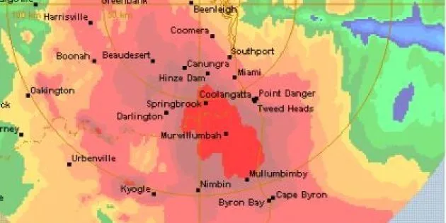
As the system tracked rapidly southwards, it turned into a tight, compact ball-shaped mass of rain-bearing cloud which pretty much parked itself over the border between the Gold Coast and northern NSW. This graphic illustrates that really well.

RAINFALL TOTALS
Springbrook, on the plateau to the immediate west of the Gold Coast hinterland, recorded the heaviest falls. According to reports, it received 900mm of rain in 48 hours, which is almost the entire annual rainfall for Brisbane, and one-and-a-half time Melbourne's average annual 600mm rainfall.
Lismore in northern NSW received a record 24 hour rainfall in excess of 400mm. The exact figure may not ever be known as the weather station has been inundated and readings ceased at 3am Friday morning.
Beaudesert had 247mm and Coolangatta had 146mm, which emphasises the fact that while the coast received heavy falls, the heaviest rain fell on the nearby ranges and valleys up to 50 km inland.
RIVER LEVELS
Across the affected area, rivers have broken their banks. A full list of north-eastern NSW river levels is here, and makes some astonishing reading.
Parts of Murwillumbah have been severely flooded, but the main part of town reportedly has dodged a bullet. The Tweed River appears to have peaked at 6.2 metres, just below the levee which sits 6.3m above the river. It's the highest flood peak in 60 years.
The Wilsons River in Lismore broke the levee. The latest word at midday Friday is that it will peak at about 11.5 metres. That's nearly four storeys above its normal level.
To put it another way. It's about two metres above the floor level of most businesses in the Lismore CBD. Which is why we're seeing scenes like this.
Channel 7 news senior reporter Chris Reason filed this report showing the breach of the town levee -- the first time this happened since the levee was built in 2005.
WHY LISMORE?
According to ABS data, Lismore is the 49th most populous town or city in Australia, with 29,000 residents. It is also notoriously flood prone. Why?
While the town gets no more annual rain on average than surrounding towns (and indeed a little less than nearby towns on the coast), it is a real flood trap.
This is really well illustrated in the Google map below. As you can see, numerous significant creeks and streams funnel into the Wilsons River just above Lismore.

FLOOD WARNINGS
There are currently eight flood warnings (including two warnings of major flooding) in place for NSW and 14 for Queensland (including four warnings of major flooding).
NATURAL DISASTER DECLARATIONS
Five local government areas in NSW have been declared natural disaster areas. They are:
- Tweed
- Lismore
- Byron
- Richmond Valley
- Kyogle and Ballina
ROAD CLOSURES
There are too many to list but the image below will give you a good idea, and you can view the road-by-road info here at myroadinfo.com.au.

POWER OUTAGES
Power was cut overnight to more than 60,000 homes across Brisbane, the Sunshine Coast and Gold Coast, but most of those homes have now had power restored.
There are power outages up and down the coast, including at least 10,000 across the NSW north coast, while the entire Lismore CBD currently has no power.
EVACUATION ORDERS
20,000 people are under flood evacuation orders in NSW.
In Queensland, the northern Gold Coast suburbs of Stapylton and Jacobs Well -- on the southern shores of Moreton Bay -- are set to be inundated early Friday afternoon. Police have begun door-knocking residents, urging them to leave.
RESCUES
300 to date in NSW as of mid Friday afternoon. Figures for Queensland are currently unavailable.
INFRASTRUCTURE DAMAGE
There are no precise figures yet, but numerous bridges and causeways have been washed away or destroyed.

AND IN LESS SERIOUS DISTURBANCES TO DAILY LIFE...
Meanwhile, the hot tip from the track is that they're not going to have the races at Lismore today. Unless they have seahorse races.
Don't count on getting a pie at the famous Yatala pie shop either.