Some extremely nasty and potentially perilous weather is striking the most populated areas of Australia right now, mixed in with some unseasonably benign temperatures. Here's a summary of what's happening. Then in a moment, we'll tell you why.
- Sydney just had an exceptionally hot night. It was 22 degrees from 3 in the morning all the way through to 6am.
- For perspective, that's four degrees WARMER than the average SUMMER minimum.
- Sydney's hot night won't count as a record for the slightly technical reason that it was much colder on Tuesday just after 9am, and official minimums are taken over a 24 hour period. But still, it was an exceptionally warm night for winter.
- It's heating up in Brisbane too, which is well on its way to a 30 degree Wednesday. That'll be no record, but the August average max is 23.
- Melbourne has had a warm spell, but both Melbourne and Adelaide are now set for a prolonged chilly spell with top temps in the mid to low teens.
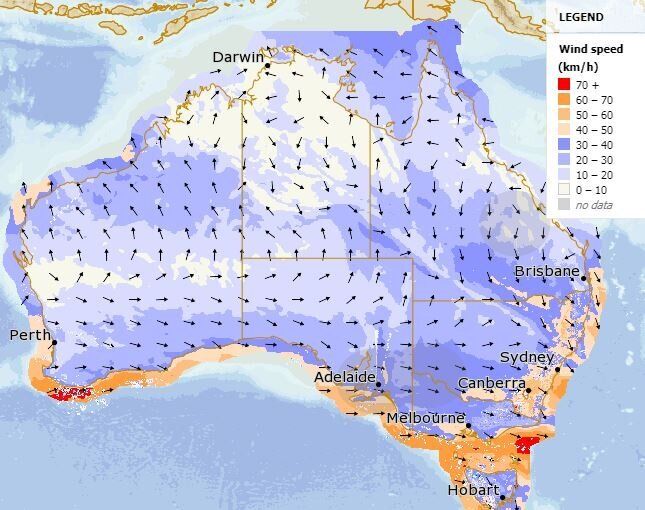
- It's dangerously windy out there. Some incredible gusts have been recorded in the last 24 hours or so. Gusts of up to 130 km/h were recorded in the NSW Snowy Mountains and the Victorian Alps. That's in the Category 2 Cyclone range.
- There are also wind gusts into the mid 80 km/h range at Sydney Airport. No word yet of any issues at the airport.
- The map below shows just how windy it is in the south-east.

Meanwhile, the Bureau in Victoria issued the following warning at 10.33am Wednesday.
A vigorous westerly airflow has become established across Victoria in the wake of a cold front.
DAMAGING WINDS, averaging 70 km/h with peak gusts of around 100 km/h are expected to persist across elevated parts (above 1200 metres) of the North East, West & South Gippsland and East Gippsland districts.
DAMAGING SQUALLS of around 90km/h are also possible along coastal parts of Victoria until this evening, most likely associated with showers and thunderstorms.
So what's going on? This is all actually a very typical late winter and early spring weather pattern for south-east Australia. The interesting thing is that unseasonable warmth is often a sign of bitter cold to follow. In other words, cold weather systems actually CAUSE the heat.
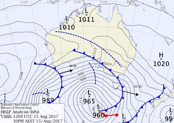
Tuesday night's weather map (below) shows why. As the strong low pressure system and cold front in the Southern Ocean push eastwards, they actually help drag down warm air from Australia's interior.

After the front goes through, it gets a lot cooler but stays windy. (The closer together the lines are on the map, the windier it is.)
It should now stay cool down south for several days now. Sydney will be windy but warm through until Thursday evening, after which it'll cool down.
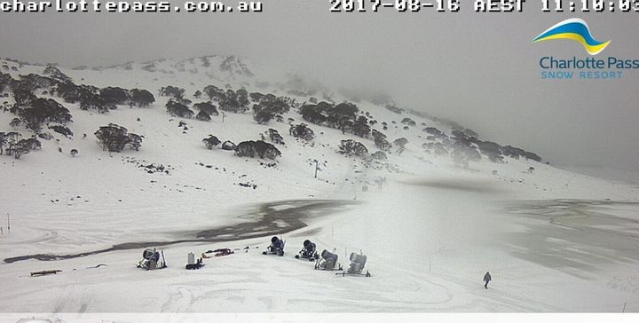
Meanwhile the ski resorts can expect a few days of snowfalls which will be welcome after heavy rain on Tuesday night. The picture below shows the NSW ski resort of Charlotte Pass on Wednesday morning. The rain has now turned to snow, but most of the resort is temporarily closed due to creeks bursting their banks and flowing across the snowfields.
