If you're in Sydney or Canberra or elsewhere on Australia's east coast right now, there's a fair chance you're looking to grab lunch or an afternoon coffee on a nice patch of lawn. If you're in Melbourne, you're no doubt huddled indoors, or wishing you were.
Autumn is finally striking the southern coastline on the eastern states. But a little further north, it's about as hot as April gets and records could be broken.
The hottest ever April day in Sydney was 33.9 on April 5, 1986. It was already 31.5 degrees just before midday with not a cloud in the sky and temperatures still rising rapidly.
At both 1 pm and 1:30 pm, Sydney was 33.8, or in other words, just 0.1 of a degree short of the record. Readings are taken half-hourly, so the mercury may well have peaked higher within that half hour slot. We'll know soon. Stay tuned.
The hottest ever Canberra April day occurred during the same hot spell as Sydney's record. It was 32.6 on April 4, 1986. That record also appears under threat, with Canberra temperatures nudging 29 just before midday and topping 30 just after 2 pm.
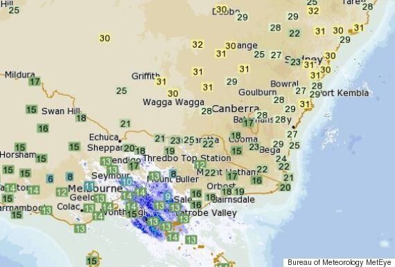
Here's a rather cool graphic representation of some of the wildly divergent temperatures in Australia's south-east on Wednesday morning.

T-shirts for some, or woolly jumpers for others.
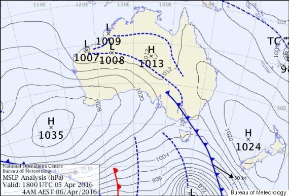
So what's going on? This map explains all. If you're not a weather nerd, we'll make it super easy for you. See the high pressure system (denoted by the letter H) parked near New Zealand? Air moves anti-clockwise around highs. So as you can see, there's a nice warm northwesterly flow of air from the interior of NSW hitting Sydney and Canberra right now.

Admit it, weather is cool.
Further south? The blue line with shark fins on it is a cold front. Behind it, cooler air from the southern ocean is impacting the southern coastline. That air will reach Sydney late Wednesday into Thursday, dragging temps back to the low 20s.
So that's what's happening on today's weather map and why it's so warm in some places today. But is this also a climate change thing?
Yes. While you can never take one weather event as evidence of a wider trend, this week's warm spell is part of a general warming trend which has been recorded in official Bureau figures almost every single month of late.
For example, Sydney recorded its warmest March on record for mean minimum temperatures this year. 2016, with the average minimum temperature 2.1 degrees Celsius above the historical average. Days were also a full 2 degrees above average. Similar anomalies were recorded in other cities.
And as we reported way down the bottom of this piece, Sydney was 1.5 degrees warmer than usual in January despite a range of factors -- like consistent heavy rainfall -- which would normally make for cooler temperatures.
The entire atmosphere is clearly warmer, which is bad news for many farmers. For example, this reporter visited an apple farm last weekend in the NSW town of Bilpin, where the farmer said he just couldn't get a certain variety to turn red because they need chilly nights for that to happen.
But it's good news for outdoor cafes on the east coast, one of which we pretty much insist you visit now if you live in Sydney, Canberra or Brisbane. Bon appetit.