Extreme weather continues to batter Australia's east coast, and while heavy rains have largely subsided for Sydney, there are warnings of huge tides in the weather system's wake.
The Bureau of Meteorology on Monday warned that high tides would exceed those experienced over the weekend, and would be greater than seen during devastating conditions in 2012.
"Average wave heights in excess of 5 metres have been recorded along the NSW coast on Sunday, with highest waves exceeding 12 metres," an advisory statement from the BOM read.
"Very heavy surf may lead to localised damage and coastal erosion this morning, possibly persisting into the day. Beach conditions in these areas will be dangerous and people should stay well away from the surf and surf exposed areas," the statement read.
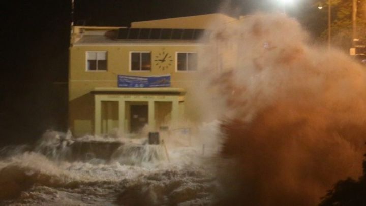
Huge tides have eroded parts of the Northern Beaches, causing the partial collapse of the beachfront venue, Collaroy Beach Club, overnight.
Residents in nearby low-lying areas around Narrabeen lake have been evacuated.
The University of NSW Water Research Laboratory, which has cameras trained on Narrabeen and Collaroy beaches, captured time lapse images showing the beaches being eroded by up to 5m.
Further south, the Coogee Surf Club was severely damaged as waves of 8m pounded the building, knocking out windows and walls, the Sydney Morning Herald reported.
"The waves that are coming in are probably eight metres in height. All the ground floor windows, the storm surge just broke them in, so we've lost all our gear downstairs. The storm surge is just pummelling it. The boatshed where we store all our equipment has been destroyed," club captain Tass Karozis told the Herald.

The storm system has shifted south, on Monday morning focused on the state's South Coast. It is expected to move out to sea on Monday afternoon.

Rain band moving over #BigWetTas tonight, then staying till late Monday, bringing heavy rain, then wind, then surf. pic.twitter.com/h2OK0yvBdE
In NSW, of the 9200 calls for help since Friday night, SES spokesperson Stephanie Sullivan said more than 280 were flood rescues.
"Across the state, there were vehicles caught in flood water," Sullivan told HuffPost Australia.
"A really common feature of east coast lows is there will be really heavy rainfall in a very quick period of time and people take chances to drive through flood waters.
"There were flood rescues in northern NSW, inland near Dubbo, and a lot down the south coast around Dapto and Wollongong.
Sullivan said it wasn't over yet.
"It is still another busy day and our focus is on the Hawksbury and Western Sydney where there are a couple of bridges down."
State Emergency Service Queensland said there were more than 1120 storm call-outs across the state with 170 from the Brisbane City Council area while in Victoria, spokesman Stefan Delatovic said Victoria SES staff were prepared for flooding.
"It does seem that Victoria has avoided the worst of the storm but there's a lot of rain in the far east so we're watching places like Gippsland for flooding," Delatovic said.
"There's a chance for short, sharp flash flooding and gradual flooding as the rain continues to fall."
Hundreds of people have been evacuated across the state in low-lying northern areas including Bilinudgel, Ocean Shores, Golden Beach, New Brighton and Coffs Creek, on the western edge of Coffs Harbour.
500 people were ordered to evacuate Lismore in the state's north, with waters peaking at around 10 metres in the late afternoon.
On Sydney's northern beaches, residents living near Narrabeen Lake were advised to evacuate due to lagoon flooding on Sunday afternoon.
Flood evacuation warnings have since been issued for low-lying areas of Sydney's southwest including Milperra, Chipping Norton, Picnic Point, Lansvale, East Hills, Carramar and Woronora.
A severe weather warming remains in place for much of eastern NSW including the Sydney metro area.
According to the BoM, damaging winds of up to 90 km/h were experienced in coastal areas south of the low on Sunday, and are expected to continue overnight.
Average wave heights of 5 metres have been recorded along the NSW coast, with the highest waves exceeding 12 metres.
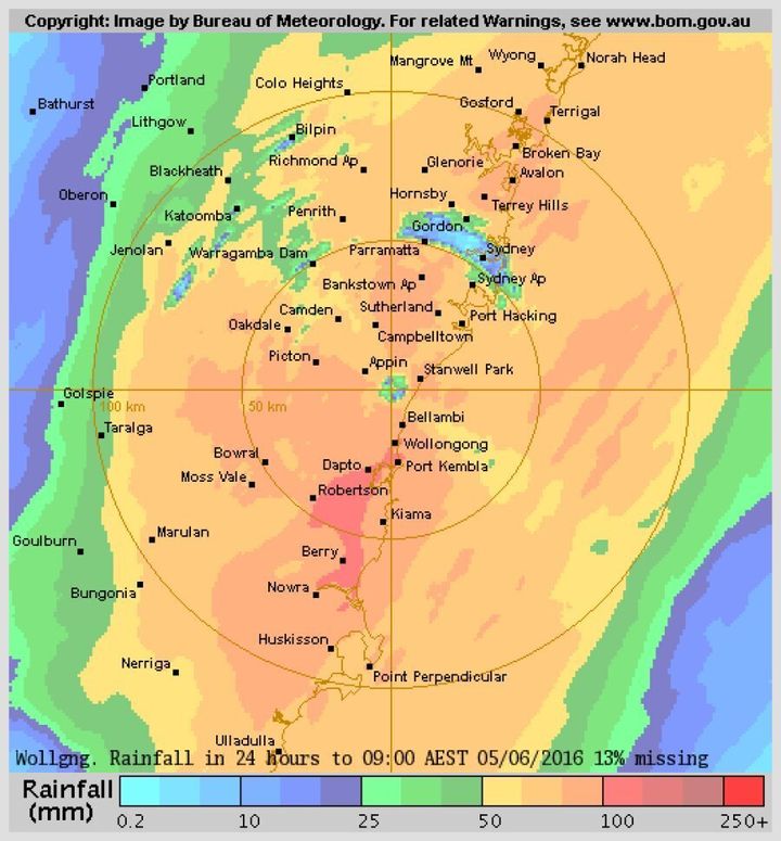
And rain totals have hit record highs, with 184mm in Robertson, 129 mm in Moruya and 133mm in Parramatta.
There are currently 23 flood warnings for rivers across NSW including The Georges River, the Hawkesbury River and Woronora.
Thousands of homes remain without power due to the intense weather system.
With the worst of the weather heading through the state's south on Sunday afternoon, the SES shifted focus to Sydney and the Illawarra.
"Over the next 12 hours or so our focus will be on Hawkesbury Nepean system and whether or not we'll lose access to some road networks in the western part out towards Penrith," SES Deputy Commissioner Mark Morrow said.
"We are unable to actually predict the exact height of the waters that are coming. We have also got extremely high tides so that adds to a very difficult mix.
"But we are actually warning people in Sussex Inlet, Basin and Shoalhaven Heads to be aware and ready to move if they need to. Other areas such as Moruya and Bega are receiving warnings as we speak as well."
He said residents in the area should look to make alternative arrangements for work on Monday as roads may be closed.
In Queensland, the weather has eased after the southeast of the state copped a soaking of up to 430mm of rain on Saturday.
An explainer on the reasons behind the current weather craziness can be read here.