The first heatwave of the year is set to sizzle across eastern Australia, and right on cue too. Summer starts on Thursday, and that's when things are really going to start warming up. In fact, parts of western NSW will hit 40 as early as Wednesday afternoon.
The good news? The worst extremes of heat won't badly affect those of us who live in cities. The bad news? Large parts of NSW and southern Queensland are going to be absolutely scorching, especially away from the coast.
The Bureau of Meteorology defines a heatwave as three or more days of high maximum and minimum temperatures that are unusual for the location. Here's the Bureau's prediction of the areas likely to be affected.
Severe to Extreme #heatwave building through QLD later this week with temperatures in low 40's. https://t.co/uJ0YPJ8dL6pic.twitter.com/A9XaVWYDi8
— BOM Australia (@BOM_au) 29 de novembro de 2016
The interesting thing about this impending heatwave is its likely duration. Bourke, in far north-western NSW, is heading for six straight days of 40-plus starting Wednesday, the Bureau says. Lots of other towns are set for temperatures in the 40s for at least four or five days.
It's doubtful that any high temperature records will fall, but plenty of towns could break the record for most days in a row over 40.
Normally, eastern Australian heatwaves last for only two or three days. They tend to be fast-moving weather systems with strong north to north-westerly winds that bring extreme bushfire risk.
This system is slower moving. That means it'll stick around longer, but it also means winds appear likely to be less strong, and that the bushfire risk -- fingers crossed -- could be slightly less severe.
OK, SO WHAT ABOUT THE WEATHER WHERE I LIVE?
Sydney will be hot, but mostly in the western suburbs where the sea breeze can't cool things down. The city will hit 31 on Friday, but then dip back into the 20s, while locations in the city's far west, like Penrith, will reach 38 Friday and stay in the mid 30s for at least four days.
Brisbane will hit 38 on Friday in the city before dropping into the mid-to-low 30s for the rest of the week. Like Sydney, though, the areas that miss the sea breeze will be up to ten degrees hotter. Ipswich, just west of Brisbane, will reach 41 on Friday and stay in the high 30s for at least four days.
Canberra will only cop a tiny bit of the heat, while Adelaide and Melbourne will miss it altogether.
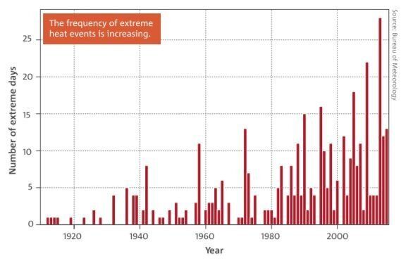
A final thought. The graph below is from the Bureau of Meteorology's 2016 State of the Climate report. It shows clearly that the frequency of extreme heat events is increasing in Australia.
When taken in conjunction with other empirical data collected by the Bureau, there is no other possible scientific conclusion except to link all of this to climate change.
Of course, a single extreme weather event like we're about to experience is not evidence of climate change. There have always been heatwaves in Australia in summer. But as the data clearly shows, the number of heatwaves is increasing.
