So dry. Just so, so dry. And warm, too.
Average maximum temperatures were 1.9ºC above average across Australia this winter, which meant they were the warmest on record. Perhaps even more remarkable is the lack of rain. Almost 200 locations set new rainfall lows this winter.
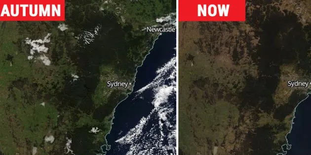
But few places have been as dry (compared to normal) as the area around Sydney. The prolonged, ongoing east coast dry spell is illustrated dramatically in the NASA satellite images above, which show the zone from about Canberra to Newcastle.
Here's a closer look.

The first image is from May 10, after a reasonably wet autumn. By September, you'd expect lush spring growth to have kicked in. But the opposite has occurred. The landscape has browned off shockingly. And still it won't rain.
The Climate Council issued a report this week called "Hot and Dry: Australia's Weird Winter". You can read it in full here. The graphic below summarises some of the key findings, which are all based on independent data from the Bureau of Meteorology.

The Climate Council says that winter warm spells are lasting longer and occurring more often. It also said that a warm winter like the one we've had was made 60 times more likely by climate change.
With normal variability, you'd expect some areas to be warmer and some areas cooler, with an overall average a little higher or lower than normal.
This winter, it was warmer virtually everywhere. Maximum temperatures in the Northern Territory and Qld were two degrees above average. Even in Tasmania and Victoria -- which both experienced exceptional snow years in the high country -- overall temperatures were above average.
When average temperatures are above normal in multiple climatic zones thousands of kilometres apart, it points to a distinct trend beyond normal variability (and a trend which climate scientists have proved beyond reasonable doubt we're causing).

And here's a chart which illustrates the trend.

Now. This map shows the increased bushfire potential for Australia this spring and coming summer.

The dry spell's effect on crops and food prices will not be known until later, but to put it mildly, solid spring rains are sorely needed across a wide section of southern and eastern Australia.
Meanwhile in Sydney, where it has rained just 1.46 mm in the past 45 days (which is barely enough to wet the ground), most people's lawns or local park would just like a really good drink.
To hear from Climate Council CEO Amanda McKenzie on life, climate change psychology and what she'd call a dating app for lonely climate scientists and researchers, listen to our totally not even slightly boring Breaking The Ice podcast here.